Let’s admit it, sometimes we need a mission, a goal, or a surprise to coax the young ones to go hiking. A geocache is usually a great carrot to get our family motivated. Once we are out exploring the geocache often becomes secondary to the adventure once the kids get the endorphins pumping and are breathing the fresh air and enjoying the great outdoors.
A few years back the Wisconsin Department of Tourism built 10 Selfie Stands in picturesque locations across the state. Tourism Secretary Stephanie Klett stated “We are excited to build on the success of the original 10 selfie stands. After all, who doesn’t love to take a good selfie? We are thrilled to provide even more Wisconsin State Park visitors an easy opportunity to snap a photo and share the beauty of our state parks.” These stands give us another target to seek out on visits to parks and sites we might have skipped over.
Each Selfie Stand features a platform to hold almost any mobile device, some even swivel up and down and side to side to capture the best shot for Instagram.
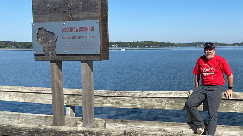
The program has now grown to 50 locations throughout the state in state parks, trails, forests, and recreational areas. We stumbled upon our first selfie stand on the Scuppernong Springs Nature Trail in Kettle Moraine Southern Unit and were the first to post a #scenicwisconsin post from that spot.
The Sheboygan Sun published this list of locations:
- Amnicon Falls State Park — South Range (Northwest region)
- Stand located downstream from the covered bridge and lower falls
- Big Bay State Park — La Pointe (Northwest region)
- Stand located at the end of the boardwalk leading to the beach
- Big Foot Beach State Park — Lake Geneva (Southeast region)
- Stand located just off the paved path about 30 feet from Ceylon Lagoon overlooking Lake Geneva (Wheelchair accessible)
- Black River State Forest — Black River Falls (Southwest region)
- Stand located at the beach by Pigeon Creek Campground
- Blue Mound State Park — Blue Mounds (South Central region)
- Stand located on the East Observation Tower at the picnic area
- Brule River State Forest — Brule (Northwest region)
- Stand located at the forest and ranger station office
- Brunet Island State Park — Cornell (Northwest region)
- Stand located at the end of black top portion of the Jean Brunet Nature Trail
- Buckhorn State Park — Necedah (Central region)
- Stand located down the paved walkway to the beachfront on the lefthand side (Wheelchair accessible)
- Copper Falls State Park — Mellen (Northwest region)
- Stand located near Brown Stone Falls on the Doughboy Trail
- Devil’s Lake State Park (2) — Baraboo (South Central region)
- Stand 1 is located on the north shore about 100 yards west of The Chateau
- Stand 2 is located on the southwest corner of the lake on Cottage Grove Road
- Elroy-Sparta State Trail — Kendall (Southwest region)
- Stand located on the west side of Tunnel 3 between Norwalk and Sparta
- Glacial Drumlin State Trail — Lake Mills (South Central region)
- Stand located on the Rock Lake Bridge just west of Lake Mills
- Governor Dodge State Park — Dodgeville (South Central region)
- Stand located at Enee Point Picnic Area
- Hartman Creek State Park — Waupaca (Northeast region)
- Stand located within the Allen Lake Picnic Arena
- High Cliff State Park — Sherwood (East Central region)
- Stand located at main park office
- Interstate State Park — St. Croix Falls (Northwest region)
- Stand located on Pothole Trail overlooking the Dalles of the St. Croix River
- Kettle Moraine State Forest, Lapham Peak — Delafield (Southeast region)
- Stand located on the west side of Highway C along the Ice Age Trail in a restored native prairie
- Kettle Moraine State Forest, Northern Unit — Campbellsport (Southeast region)
- Stand located south of Mauthe Lake on the Tamarack Trail
- Kettle Moraine State Forest, Pike Lake — Hartford (Southeast region)
- Stand located on the Ice Age Trail overlooking Pike Lake
- Kettle Moraine State Forest, Southern Unit — Eagle (Southeast region)
- Kinnickinnic State Park — River Falls (Northwest region)
- Stand located at the St. Croix Overlook (Wheelchair accessible)
- Kohler-Andrae State Park — Sheboygan (East Central region)
- Stand located at lot #3 at Sanderling Nature Center
- Lake Kegonsa State Park — Stoughton (South Central region)
- Stand located at the beach
- Lake Wissota State Park — Chippewa Falls (Northwest region)
- Stand located at Lakeview scenic outlook (Wheelchair accessible)
- Lakeshore State Park — Milwaukee (Southeast region)
- Stand located on Hank Aaron State Trail (Wheelchair accessible)
- Lower Wisconsin Riverway — Muscoda (Southwest)
- Stand located at Peck’s Landing along Highway 23 by Spring Green
- MacKenzie Center — Poynette (South Central)
- Stand located in front of Nelson Cabin in the “Maple Area” (Wheelchair accessible)
- Menominee River State Recreation Area — Crivitz (Northeast region)
- Stand located at Quiver Falls Overlook off Pemene Dam Road (Wheelchair accessible)
- Merrick State Park — Fountain City (Southwest region)
- Stand located near North Boat Landing
- Mirror Lake State Park — Baraboo (South Central region)
- Stand located at the boat landing (Wheelchair accessible)
- Nelson Dewey State Park — Cassville (Southwest region)
- Stand located in the picnic area
- Newport State Park — Ellison Bay (Northeast region)
- Stand located in picnic/beach area near parking lot #3
- Northern Highland/American Legion State Forest — Boulder Junction (Northwest region)
- Stand located at Crystal Lake Campground/day use area in the center of the main beach
- Pattison State Park — Superior (Northwest region)
- Stand located at south overlook of Big Manitou Falls (Wheelchair accessible)
- Peninsula State Park — Fish Creek (Northeast region)
- Stand located at Eagle Panorama
- Perrot State Park — Trempealeau (Southwest region)
- Stand located on the boardwalk overlooking Trempealeau Bay (Wheelchair accessible)
- Peshtigo River State Forest — Crivitz (Northeast region)
- Stand located at the boat landing 9 picnic area overlooking Cladron Falls
- Point Beach State Forest — Two Rivers (Northeast region)
- Stand located near Lake Michigan and the Rawley Point Lighthouse
- Potawatomi State Park — Sturgeon Bay (Northeast region)
- Stand located at Old Ski Hill overlook
- Red Cedar State Trail — Menomonie (Northwest region)
- Stand located at the first picnic area along the trail, approximately 1.5 miles south of Menomonie Trailhead (Wheelchair accessible)
- Rib Mountain State Park — Wausau (Central region)
- Stand located in Lower Picnic Area during summer and fall (Wheelchair accessible)
- Roche-A-Cri State Park — Friendship (Central region)
- Stand located on righthand side of petroglyphs viewing platform (Wheelchair accessible)
- Rock Island State Park — Washington Island (Northeast region)
- Stand located at the trailhead of Michigan Avenue
- Sand Valley Golf Resort — Nekoosa (Central region)
- Stand located at Sand Valley along The Ridge Trail near Mammoth Dunes’ 14th hole
- Whitefish Dunes State Park — Sturgeon Bay (Northeast region)
- Stand located on the observation deck
- Wildcat Mountain State Park — Ontario (Southwest region)
- Stand located at the observation point in the upper picnic area of the park
- Willow River State Park — Hudson (Northwest region)
- Stand located on the bridge overlooking Willow Falls
- Wyalusing State Park — Bagley (Southwest region)
- Stand located at Henneger Point (Wheelchair accessible)
- Yellowstone Lake State Park — Blanchardville (Southwest region)
- Stand located near park office overlooking Yellowstone Lake (Wheelchair accessible)